Broome Boating Facility

Overview

The Shire of Broome has been working closely with the Department of Transport to design and construct a safe boating facility for Broome that best meets the area's challenging tidal conditions and the needs of boat users.

This is a project that the Shire of Broome strongly supports and has been a significant contributor through the coordination of the Broome Boating Facility Advisory Group.

The development of a safe boating facility in Broome has long been considered essential to address critical safety and access difficulties associated with boat launching and retrieval, and passenger transfer between vessels and shore.

Large tides, strong currents, wind and waves can at times create a hazardous environment at the existing exposed beaches and boat ramps where conditions can change very quickly.

The current facilities do not meet the Australian Design Standards for Maritime Facilities (AS3962) and are below the standard of most other regional towns.

The first study into possible locations began in 2003.

Broome is a complex and difficult area to design maritime facilities, and there have been many studies and investigations into a suitable location, including draft designs, over many years.

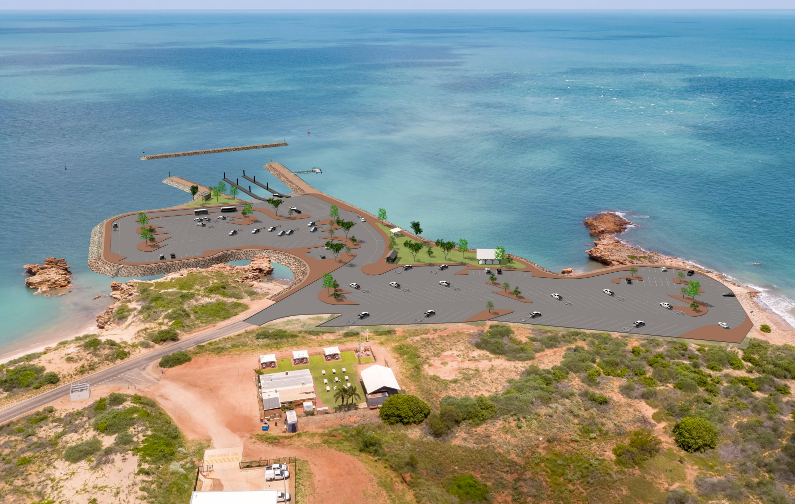
Proposed Location - Entrance Point

BBF MAIN PIC.PNG

Cost

In 2020, the Broome Boating Facility was estimated to cost $77 million. The state government has so far committed $36 million. 

Concept Design

BBF Concept Plan Hi Res
 
Click here(PDF, 9MB) to download a high-resolution image.


Project Timeline

If viewing on mobile you may need to rotate phone to view in full.

2003
Broome Boat Harbour Steering Committee Group releases study into possible locations for a safe boat harbour
2010 
State Government approved funds ($35M) for a new boat harbour in Broome.
2010 - 2013
Previous State government funding and planning for a Small Boating Facility in Broome was abandoned due to high costs and concerns over the site suitability in West Roebuck Bay.
December 2013
Shire of Broome developed the Boat Harbour CEO Advisory Group, this became the Broome Boat Harbour Advisory Group (BBHAG) in July 2016.
2016
The Broome Boat Harbour Advisory Group established. Chaired by the Shire, and included Yawuru, Landcorp, Department of Transport, Kimberley Port Authority, Kimberley Development Commission, and community group representatives.
September 2017
$1 million provided by the Western Australian State Government for new planning and investigations to proceed.
January 2018 - February 2019
Investigations into a boat harbour facility at Reddell Beach were undertaken but not supported by the BBHAG following the identification of dinosaur trackways in the area (West Kimberley National Heritage Zone).
February 2019 - December 2019
Investigation into co-location opportunities with the Kimberley Marine Supply Base (KMSB) for a site between Broome Port and Entrance Point were undertaken. This location was ultimately not supported due to rich cultural and heritage values identified through a detailed heritage study of the area.
December 2019 - January 2020
The BBHAG completes preliminary planning and recommends a design option at Entrance Point. The BBHAG changes name to the Broome Boating Facility Advisory Group (BBFAG).
Early 2020
A preferred design concept is endorsed and used to seek community feedback.
March 17 - April 15 2020
The Broome Shire Council resolves to support the Broome Boating Facility concept and to commence further Community Consultation and engagement.
April - June 2020
Preparation of detailed designs for the boating facility proposal and development of a funding proposal for government consideration.
August 2020
A final concept is prepared based on feedback and design refinements.
2021
Broome Boating Facility Business Case completed by Department of Transport (DoT) and estimates the capital cost at $77M. The Western Australian State Government commits $36M.
December 2021
DoT submit the Broome Boating Facility proposal to State and Commonwealth environmental agencies for assessment.


Frequently Asked Questions

BBF aerial.PNG

Why has this location been chosen?

Broome is a complex and difficult location to design maritime facilities and a significant number of factors have contributed to the most recent design option located at Entrance Point.

The development of this option at Entrance Point represents a significant safety and access enhancement to the existing boating launching activity at this site. 

Key influencing factors: 

  • A need to locate the facility close to deep water so that the extreme tidal range does not excessively limit the functionality while avoiding dredging. There are good water depths close to shore at Entrance Point. 

  • A strong desire to minimise impacts to the environment and culturally sensitive areas, including impacts to the marine and land environment including dinosaur trackways. The site at Entrance Point and within the Port’s operational area has been extensively assessed. 

  • A need for an appropriate amount of land for car and trailer parking to accommodate busy periods. The existing parking area at Entrance Point can provide a significant amount of this capacity. 

  • An ability to work with and/or address challenges created by tides, winds, waves and currents. Extensive computer modelling and testing has been conducted on this site and this has informed the design. 

  • The location is already being used for boat launching 

  • The is strong local support for this location. 


What studies and investigations have been completed to date?

The project has placed a high value on understanding, working with and finding solutions around matters of local concern.

These include environmental issues and areas of local cultural and heritage concern while ensuring the facility design works well within the dynamic marine environment. 

Extensive work with the local Yawuru community to map and investigate areas of cultural, heritage and environmental sensitivities was completed in December 2019. This has helped inform the current concept.

Mapping of areas of Broome sandstone was also undertaken to determine where dinosaur trackways may be present. 

Additional studies and technical work have been completed around land and marine environmental aspects and computer modelling has been completed to understand and assess the coastal and marine processes against the facility design.

This work has facilitated design refinements to the marine structure’s size, shape and cost. 

Will the beach at Entrance Point still be accessible?

The beach area at Entrance Point will still be accessible to the public. The design will include a universal access ramp and stairs to ensure access to all of the beach areas.

bbf2.PNG


What is the proposed configuration of the ramps and jetties at the facility?

The current design proposes a four-lane boat ramp with two floating jetties and adjacent parking. The configuration is designed to reduce congestion. 

The inclusion of two jetties improves safety and reduces delays by providing a separate launch and retrieval jetty. Jetties are used to safely hold vessels, particularly while the towing vehicle is being parked or returned to the ramp. Floating jetties move with the tide and significantly improve access to and from vessels. 

The parking capacity is designed to meet the criteria as set down within the published Australian Standards for the design of these facilities. 


What is the purpose of the offshore breakwater and why is it detached from the shore?

Detailed investigations into the wind, waves, sand movement and currents in and around the proposed facility determined that sheltering of the ramp will be required to ensure the facility can be used safely, and that detaching the breakwater is the best solution. 

The design of the detached breakwater was tested through computer modelling and was refined to ensure the design will reduce wave heights at the ramp. The design meets the requirements of the Australian Design Standards. 


Will the facility be able to be used at all stages of the tide?

The design locates the boat ramp toe at about 0.5 metres above the Chart Datum for Broome.

The term Chart Datum is generally associated with the definition of the lowest water level likely to occur in that location.

As Broome has tides that range up to approximately 10 metres above chart datum, and extremely low tides (+0.5m or lower are infrequent and only occur for short periods of time), the percentage availability of the ramp for small vessels will be very high.


Will the facility include boat moorings or pens?

No. With more than 90 per cent of boats in Broome being trailer-based and the area of greatest demand and risk relating to trailer boat operations, the facility design is strongly focussed on getting boats in and out of the water more safely and facilitating safer passenger transfer.

The facility will include jetties to hold vessels during launching and retrieval. 

The provision of boat pens in Broome’s extreme tidal range would likely involve the creation of a marina with a lock, which is less suited to trailer boat operations.


What is the maximum size vessel that can use the facility?

The facility has been designed around use by trailer boats. Vessels in this category are predominantly in the 5 to 8 metres range, noting vessels up to 10 metres are sometimes trailered. 

There will also be the opportunity for larger visiting vessels to utilise the jetties for passenger transfer subject to vessel length, draft and the tide.  


What facilities and amenities will be included?

The facility will include landscaping incorporating public facilities and amenities such as public open space, restrooms, shade shelters, artwork and interpretive design and signage.

More detail will be developed through the landscape design phase.


How much parking will be available at the facility?

The current design includes capacity for 160 trailer parking bays and approximately 80 single car bays which meets the Australian Standards for these types of facilities.

It is important that capacity is available to deal with busy periods. Parking will include a mix of boat trailer parking bays and single-vehicle parking bays.


Will the existing ramps be available during construction of the new facility?

It is expected that the existing ramps at Entrance Point will be closed during the development of the new boating facility due to their proximity to the construction activity.

The closure timeframes involved will be dependent on the construction contract work schedule. Closures and consideration around alternative arrangements will be clearly communicated ahead of any works proceeding.


What will happen to the existing ramps once the new facility is built?

The dual northern ramps at Entrance will be replaced by the new facility and be de-commissioned.

The southern ramp is more exposed and is at times hazardous and is expected to become redundant.


How much will the new facility cost?

The cost estimate was determined during the detailed design phase and the development of the business case for the project in late 2020, with a total cost of approximately $77 million in its current format.


How much money has been committed to the project?

The State Government has so far committed $36 million to the project.

When will construction commence?

There are several pre-requisites before construction can commence.

These include securing government commitment and funding, finalising the design in detail, and securing all necessary approvals including environmental approvals.