How Ex-TC Ellie is impacting the Shire of Broome
Published on 04 January 2023

UPDATED: Friday, January 6, 10.30AM
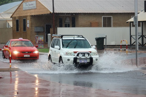
Ex Tropical Cyclone Ellie's slow movement west from the Central Kimberley has seen communities across the Shire of Broome, including the town of Broome, experience signicant rainfall and coastal-gale-force winds that are expected to continue until Friday, January 6.
This has resulted in localised flooding, and while there have been no reports of properties being inundated within the Shire, there is a high risk of urban flooding around Broome, Lombadina Community, Bidyadanga Community, Cape Leveque, and Roebuck Plains.
For the latest flood information visit www.bom.gov.au/wa/flood or call 1300 659 213.
State of Emergency
A
Level 3 Incident has now been declared. A State of Emergency has also been declared, as a result there will be no takeway alcohol sales within the Shire of Broome until Friday, January 6, though this could be extended if the situation remains unchanged.
Road Closures
Roads across the Shire of Broome currently closed include:
- Great Northern Highway is now closed between Roebuck Roadhouse and Sandfire.
- Great Northern Highway between Roebuck Roadhouse and Wilare Rodehouse (towards Derby) - this is temporarily open this morning, with heavy rain in the direction likely leading to further closures.
- Kavite Road (unsealed)
- Crab Creek Road (unsealed)
- Fairway Drive (past the seal)
- Manari Road (unsealed)
- Quondong Point Road (unsealed)
Cautions
The rain has caused a number of potholes on streets around Broome. Shire workers are respoonding to reports and checking streets to identify road damage, which will be marked and then repaired as soon as possible.
Click here for more information about Shire of Broome road closures.
Main Roads WA is concerned about the potential for Cape Leveque Road to be damaged and closed if rainfalls are high.
The Great Northern Highway is still open to the north and south of Broome, but extreme caution is advised if travelling between Roebuck Roadhouse and Willare Roadhouse towards Derby.
For information about main road closures, including the Great Northern Highway and Cape Leveque Road, visit https://travelmap.mainroads.wa.gov.au/Home/Map
The Kimberley Ports Authority has closed the boat ramps at Entrance Point, Broome.
If driving in this weather:
- Floodways and river levels may rise rapidly so be careful at crossings.
- Obey road closure signs and do not drive into water of unknown depth and current.
- Take care on gravel and unsealed roads as they may be slippery and muddy, and you could get bogged.
- If your car stalls in rising water, abandon it immediately and seek shelter above floodwater.
Shire of Broome Facilities
As of 9AM, Friday, January 6, Shire of Broome facilities including the Administration Building, Library and Broome Recreation and Aquatic Centre are open.
Waste Management Facility
The Shire of Broome Waste Management Facility is partially open from 9AM to household perishable items and green waste ONLY, for people whose weekly rubbish collection has been affected by the weather. All other loads will be turn turned away due to flooding across the site. For more information phone the WMF Staff on 9191 8775 or the Shire on 9191 3456
Kerbside bin collection
continues. For inquiries, phone Cleanaway on 9194 5200.
Town Beach Waterpark
The waterpark is closed due to the unfavourable weather conditions, which has also led to the road leading to the jetty carpark being closed.
Updates
The Shire of Broome will update information when when it comes to hand. But please note, the Shire is not the primary source of local weather and flood warnings, or emergency calls.
For emergency and weather warnings and updates please visit the Department of Fire and Emergency Services WA and/or Bureau of Metoerolgy, or listen to ABC Kimberley radio, 675 AM.